PARSEC sectors: EO, Food
Application fields: Agriculture, Construction, Forestry, Local and regional planners, Minerals & Mining, Oil and Gas, Transportation
Keywords: deforestation, deformation, disasters, infrastructure, InSAR, mapping, raw materials
When Golden Earring famously sang the lyric “We’ve got a light in the sky, radar love” all the way back in 1973, little did they know just how much those “lights” (or radars) in the sky would add to our world years later. Just like in the song “Radar Love”, industry is continually learning to further “love” and adopt the use of radar in more and more imaginative applications. One radar technology, InSAR, has been particularly versatile and impactful. InSAR (short for Interferometric Synthetic-Aperture Radar) is a remote-sensing technique which can generate maps of surface deformations and elevation gradients. It can be used in a plethora of applications, from monitoring the movement of the earth’s gigantic tectonic plates, to measuring with millimetre precision the displacement of dams. InSAR has proven itself to be a technology that has made our lives safer, our practices more efficient and the understanding of our earth deeper.
First, let us start with the technical description of how a Synthetic-Aperture Radar (SAR) system actually works. A SAR system emits microwave pulses (with a wavelength ranging from few centimetres to few tens of centimetres) and records the echoes from each pulse. The time taken for the echo to arrive provides the distance between the satellite and the measurement point on the ground. The energy that is reflected or scattered back from the ground provides important information on the surface. Since microwave radiation penetrates the atmosphere with negligible absorption, SAR is capable of operating during all weather conditions and at night. These properties for all-weather and night-day acquisitions make this technology very appealing for Earth surface monitoring purposes. “InSAR” then uses two or more SAR images of an area to identify surface movements through time.
InSAR is a very well established technology which has proven to be extremely reliable and precise in its application. It is also fast becoming a technology that more and more huge industrial sectors are relying upon to improve their products and services. The extraction of raw materials such as iron ore, coal or crude oil, amongst many others, play extremely important roles in many economies and form a huge global sector in their own right. The raw materials sector is constantly looking for innovative ways to increase their extraction efficiency, minimise their environmental impact and raise their safety standards. Mining companies can benefit greatly from the use of InSAR to monitor ground movement above their operations, allowing them to keep an eye on any potential breaches in safety, keeping both their mines and the general public safe. Forestry and logging companies can also benefit from the use of InSAR to monitor the environmental impact and sustainability of their operations. In fact, raw materials will be a sector of major expansion and a focus for national governments in the future, given its strategic, political and economic importance. In their communication entitled “A New Industrial Strategy for Europe” the EU Commission have explicitly stated:
“To become more competitive as it becomes greener and more circular, industry will need a secure supply of clean and affordable energy and raw materials. Stepping up investment in research, innovation, deployment and up-to-date infrastructure will help develop new production processes and create jobs in the process.”
They go on to emphasise that as the demand for raw materials doubles by 2050, a secure supply of raw materials is crucial for markets such as e-mobility, batteries, renewable energies, pharmaceuticals, aerospace, defence and digital applications. A key takeaway from this communication is the fact that an “Action Plan on Critical Raw Materials” is being rolled out to broaden international partnerships and secure supply. InSAR will undoubtedly play a part in helping the EU to achieve this vision.
There are numerous sources of funding for InSAR related innovations which can open doors for prospective entrepreneurs wishing to apply the technology in exciting ways. Horizon 2020 has already funded projects which utilise InSAR, such as “So2Sat”, which exploits big data from social media and satellite observations for global urban mapping and “GATHERS” which furthers expertise in the multi-technique monitoring of ground deformations and seismicity. The European Space Agency also have a funding scheme called “Kick-start Activity” which amongst other technologies, promotes the innovative use of InSAR and can be a great opportunity for burgeoning start-ups to make waves in the sector.
As previously mentioned, the use of InSAR is widespread, and can be seen in such applications as the monitoring of deforestation, the assessment of damage caused by natural disasters and is even adopted in the planning and construction of ultra-modern smart cities. One novel example of the application of InSAR is in the little known, yet extremely important activity of aquifer management. In semi-arid areas such as agriculture-heavy Murcia in Spain, productivity is often hit by severe droughts. This combination results in extreme strain on the management of water resources, which, in the absence of other viable alternatives, often results in overexploitation of the aquifer. The impact of overexploitation can be devastating, leading to ground deformation that can cause building damage and aquifer depletion, while endangering water quality, reducing the productivity of agricultural soils and threatening protected natural areas. The responsible water authority in Murcia, CHS, contracted services from DARES – an innovative Barcelona-based company and IGME – the Spanish Institute of Geology, to produce regular ground deformation maps based on InSAR measurements. This has allowed CHS to make better, informed decisions on the sustainable management of the aquifer.
It can be surprising which industries are able to reap the benefits of the technology. Take the example of Kayrros – a fast growing French start-up who use InSAR to offer services to the energy and finance industries. Kayrros in particular demonstrate just how quickly and effectively InSAR can help boost your business. From their inception in 2016, they now have offices in six countries around the globe and boast over 150 employees. They use InSAR to provide energy companies and commodity traders with more precise and timely information on movements within the crude oil market. Knowing more about the current locations of oil inventories as well as where they are moving, gives any trader a better overall understanding of the market, allowing them to buy and sell at optimum times. Crude oil is typically stored in tanks in which the roofsfloat on top of the oil content inside the vessel, meaning the roofs rise or fall as crude oil is pumped in or out of the tank. InSAR allows for the monitoring of the heights of these roofs worldwide. This data can then be processed to build a global picture of crude oil inventories. Market actors can then use this information to make better informed business decisions. This encourages market competition and ultimately drives prices lower for end users.
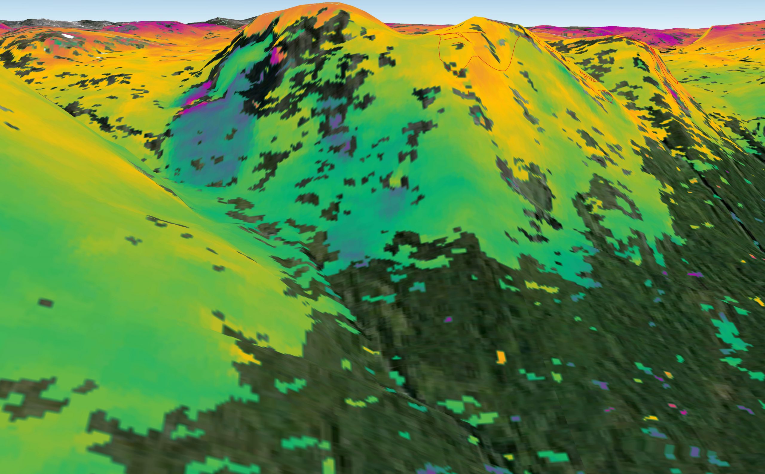
Another example of the application of InSAR is exemplified in Norway, where the Norwegian Space Agency and the Geological Survey of Norway have created a mapping service which monitors ground motion over the entire expanse of Norway. “InSAR Norway” is freely available to the public and allows users to detect and monitor areas where subsidence is occurring. The Norwegian Public Roads Administration quickly became one of the service’s many users, adopting it at the design, construction and operational phases of numerous road and public infrastructure projects. From gaining insights into historic ground conditions to monitoring the settlement of foundations, InSAR Norway can holistically add value to road infrastructure development. The Norwegian Geological Survey also use the map for identifying and classifying mountain sides and fjords which are at risk of landslides or tsunamis, ensuring that the public, housing and infrastructure remain safe throughout the country.
Traditionally, government funded space programmes were the providers of InSAR missions and data, however, this is rapidly changing. New constellations of smaller satellites are being launched and operated by private companies, driving competition in the sector and improving the resolution, capabilities and service offering year-on-year. Companies such as Capella Space are developing and launching their own constellations of high resolution SAR satellites, providing customers with the latest information on any spot on the planet within an hour, right down to a resolution of 0.5 metres. ICEYE are a company who are also continually developing their own SAR enabled satellite constellations, providing solutions to the food, energy and environment industries, in the forms of services such as agricultural monitoring, fracking monitoring and deforestation monitoring, to name but a few.
It is clear that InSAR can bring incredible value to our lives and economies, with its capabilities and applications constantly evolving and improving. The real-world implications and uses of the technology will no-doubt continue to impact society and business as the years go on. Harnessing the capabilities of the technology and implementing it in novel and exciting ways may open up promising new horizons for start-ups seeking to set themselves apart and ahead of the competition.
Leave A Comment
You must be logged in to post a comment.